13 Best Running Routes in the Sutherland Shire | Evolve
The best running routes in the Sutherland Shire cover four categories. Easy long runs along Cronulla Esplanade, Taren Point and Kurnell. Trail running through Royal National Park including Lady Carrington Drive and the Bundeena Coast Track. Hill loops in Burraneer, Kareela and Engadine. Track sessions at Sylvania Waters and Barden Ridge. This guide covers 13 routes with distance, elevation, parking and the training session each one suits.
The Shire has a running problem, and it isn't a lack of routes. The terrain in this corner of Sydney offers more variety than most local runners use, but the default for most people is the same Cronulla Esplanade loop for every session, week after week. Easy day, long run, tempo, all on the same flat path. The way you mix it up is one of the levers that matters for how you progress as a runner.
This guide is built for runners with some base under them. Not absolute beginners, not elites. Everyday athletes preparing for races from 5km through to ultras, who want to know where to run for the sessions in their week. We coach these routes with Evolve athletes every week from our base in Caringbah, so the recommendations below are the ones we actually use with runners like Mitch, Tammy, Rohan and Kara, not just the ones that show up in Google. If you want help putting these into a structured program, see our run coaching page.
Thirteen routes across four categories. Easy long runs, trail runs, hill loops, and session locations. Each route includes distance, elevation, surface type, parking, water, public transport, and what kind of training session it actually suits. The quick reference table below lets you scan the lot before reading on.
Quick reference: every route at a glance
| Route | Distance | Elevation | Surface | Best For |
|---|---|---|---|---|
| Easy Long Runs | ||||
| Cronulla Esplanade to Bate Bay | 6-15km flex | Flat | Paved | Default easy long |
| Taren Point to Brighton Foreshore | 12-30km | One bridge incline | Paved shared path | Less busy easy long |
| Kurnell Silver Beach Foreshore | ~3km extendable | Flat | Paved | Quietest easy long |
| Trail | ||||
| Temptation Creek Loop | ~7km loop | 177m | Fire trail | Trail entry point |
| Cape Baily Track | 6.4km return | Rolling clifftop | Mixed track | No-ferry trail run |
| Bundeena to Marley Beach | ~10km return | Rolling clifftop | Coastal track | Adventure trail |
| Lady Carrington Drive | ~20km return | ~450 | Dirt/gravel | Trail long run |
| Hills | ||||
| Burraneer Hill Loop | 7km loop | 154m | All paved | Hill reps |
| Kareela / Jannali / Oyster Bay | ~9km loop | 276m | Path | Sustained hills |
| Engadine to Yarrawarrah | ~9km return | 190m | Paved footpath | Rolling hilly aerobic |
| Sessions | ||||
| Sylvania Waters Athletics Track | 400m track | Flat | Synthetic | Interval sessions |
| The Ridge Athletics Track, Barden Ridge | 400m track | Flat | Synthetic | Backup track option |
| Green Hills Estate Loop | 1.9km loop | Flat | Sealed road | Tempo blocks |
Where Are the Best Easy Long Run Routes in the Sutherland Shire?
Easy running is where most of the weekly mileage should sit. Not because it is the impressive part of the training week, but because it is the part that builds the engine and lets the harder sessions deliver. Heart rate stays low, conversation should be possible, perceived effort should feel sustainable for hours. We have written before about why new runners should not just run more and the role aerobic volume plays in long-term development. For everyday athletes, the right routes for this work are flat, predictable, and free of stop-start interruptions. The three options below are the ones that work.
1. Cronulla Esplanade to Bate Bay
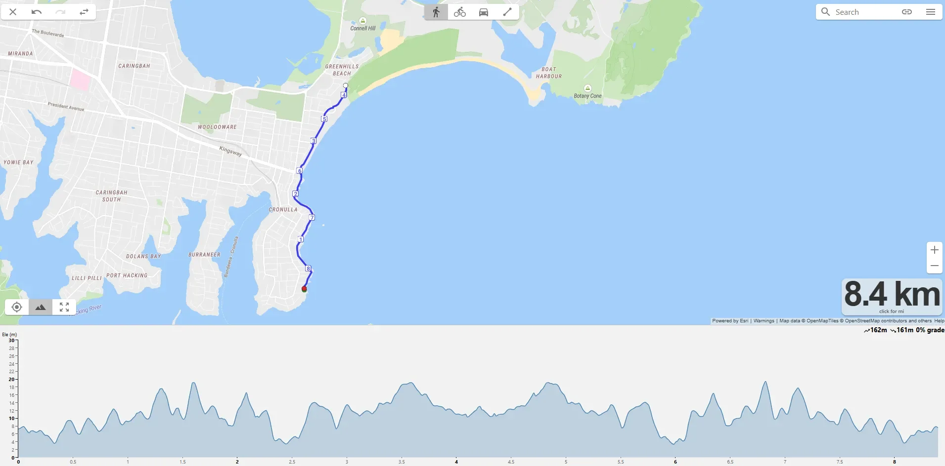
Distance: 6-15km flexible out-and-back | Elevation: Flat | Surface: Paved promenade
Cronulla Esplanade running route
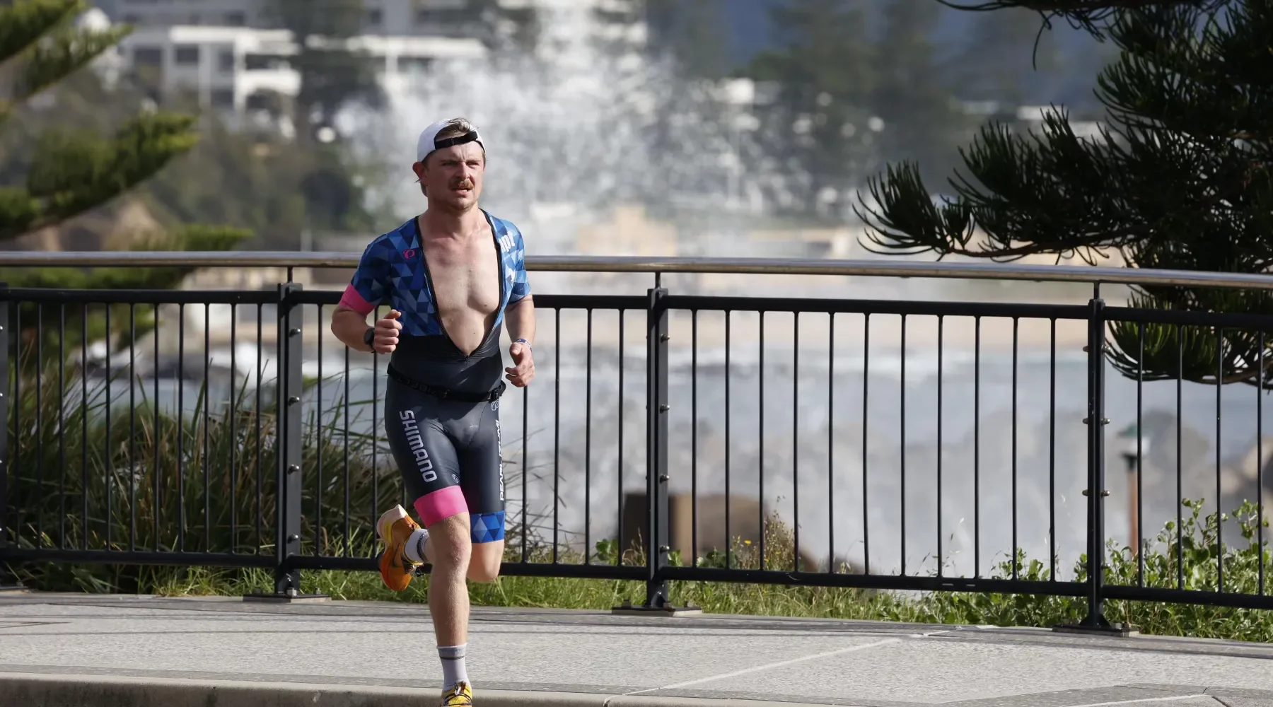
The default. Where most Evolve athletes including Josh and Riley do the bulk of their easy mileage. The Esplanade runs from Cronulla Park south along the beachfront and gives you a smooth, predictable, traffic-free surface that is easy to pace. You can stretch it out as far as Bate Bay and back, which puts a long run comfortably in the 14-18km range depending on where you start. In summer the sea breeze keeps you honest, in winter it is exposed but rarely cold enough to matter.
Best used for aerobic base building, recovery runs, easy long runs. Not the route to choose if you want hill exposure or variation in surface. The Esplanade is flat by design, which is the point.
Parking: Cronulla Park car park (paid), street parking along The Esplanade, or train to Cronulla station and run from there.
Toilets: Multiple public toilet blocks along the Esplanade, including Cronulla Park and Wanda.
Water: Drinking fountains at most beach access points and parks.
Public transport: Cronulla railway station, 5-10 minutes walk to the start.
Best for: Easy long runs, recovery, marathon-pace work.
Avoid: Saturday mornings if you want quiet. Peak summer afternoons without sun protection.
2. Taren Point to Captain Cook Bridge to Brighton Foreshore
Distance: 12-30km out-and-back | Elevation: Flat with one bridge incline | Surface: Mixed shared path
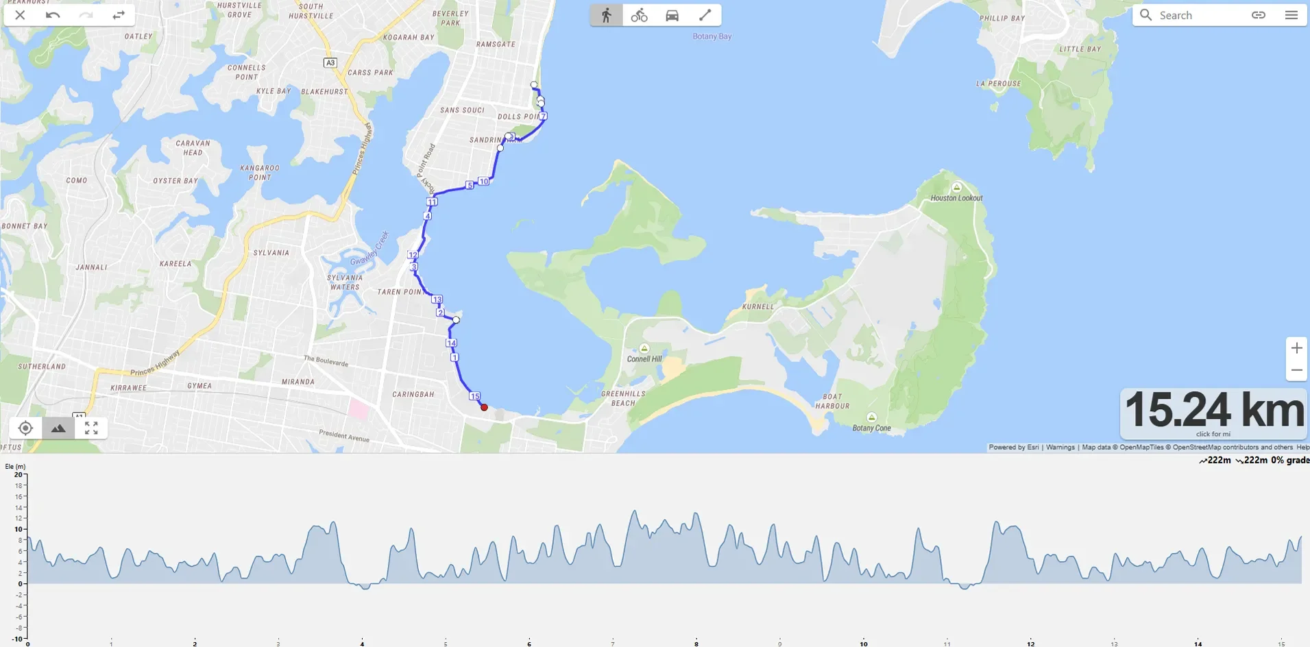
Taren Point to Brighton Foreshore running route
The Shire's most underrated long run venue. Start near Taren Point, head north along the foreshore, cross the Captain Cook Bridge into Brighton-Le-Sands and continue along the Botany Bay foreshore. Water on one side the whole way. Far less foot traffic than Cronulla, particularly on weekends, which makes it ideal for sustained efforts where you don't want to weave around prams and dog walkers.
The bridge incline is the only elevation on the route, but it is a useful kicker. Coming back over the bridge with 15km already in the legs is a small reminder that flat doesn't have to mean monotonous. Marathon training plans benefit from this kind of late-run resistance.
Parking: Captain Cook Field area or street parking around Taren Point. Brighton-Le-Sands end has metered street parking.
Toilets: Toilets along the route.
Water: Water fountain access.
Public transport: Less convenient than Cronulla. Car access is easiest.
Best for: Easy long runs where you want fewer interruptions, marathon-pace progression.
Avoid: Strong southerly days. The foreshore is fully exposed to wind.
3. Kurnell Silver Beach Foreshore
Distance: ~3km along Silver Beach to Bona Point, extendable | Elevation: Flat (grade toward the lookout) | Surface: Paved promenade
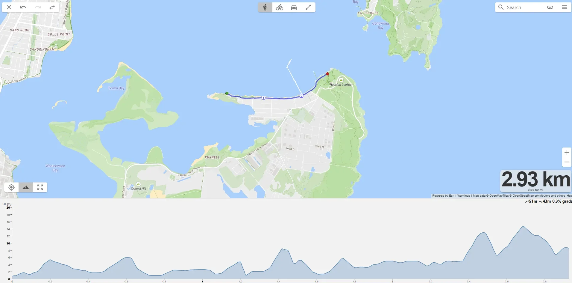
Kurnell Silver Beach Foreshore Running Route
Most Shire runners forget Kurnell exists. The Prince Charles Parade promenade runs flat along Silver Beach from the Visitor Centre area to Bona Point, with water on one side and the bay opening up to the south. Quieter than Cronulla, gentler wind exposure, and the views across to the Royal National Park give you something different to look at while you accumulate kilometres.
The base route is 2km one-way. To turn it into a real long run, double back and run it again, or combine with the inland Banks-Solander track for a mixed-surface option that adds a couple of kilometres on softer ground.
Parking: Important note: Kurnell Visitor Centre is currently closed for the Kamay Botany Bay Masterplan upgrade and parking is limited. Check the NSW National Parks site before going. Street parking along Prince Charles Parade is available.
Toilets: Public toilets along Prince Charles Parade.
Water: Drinking fountain near the southern end of the parade. Otherwise bring your own.
Public transport: Limited. Car access recommended.
Best for: Easy long runs when you want a change from Cronulla, longer aerobic work.
Avoid: Strong easterlies. The route is fully exposed to the bay.
Where Can You Trail Run in the Sutherland Shire?
Trail running matters for road runners more than most realise. The aerobic stimulus is similar to road, but the terrain forces ankle stability, foot proprioception, and recruitment patterns that don't show up on a flat path. For runners managing recurring lower-leg issues, regular trail work tends to build resilience that translates back to road performance. It is also a different kind of stress on the body, which connects directly to the chassis-building work we do in the gym.
The Shire is lucky here. Royal National Park is one of the best trail running venues in Sydney, and Kurnell offers a closer alternative that doesn't require the Bundeena ferry. Four routes below, ordered roughly by accessibility. All Royal NP routes require a $12 vehicle entry fee, payable at Audley Visitor Centre or via the Park'nPay app.
1. Temptation Creek Trail / Florence Parade Loop
Distance: ~7km loop | Elevation: 177m | Surface: 100% unpaved fire trail | Grade: Easy
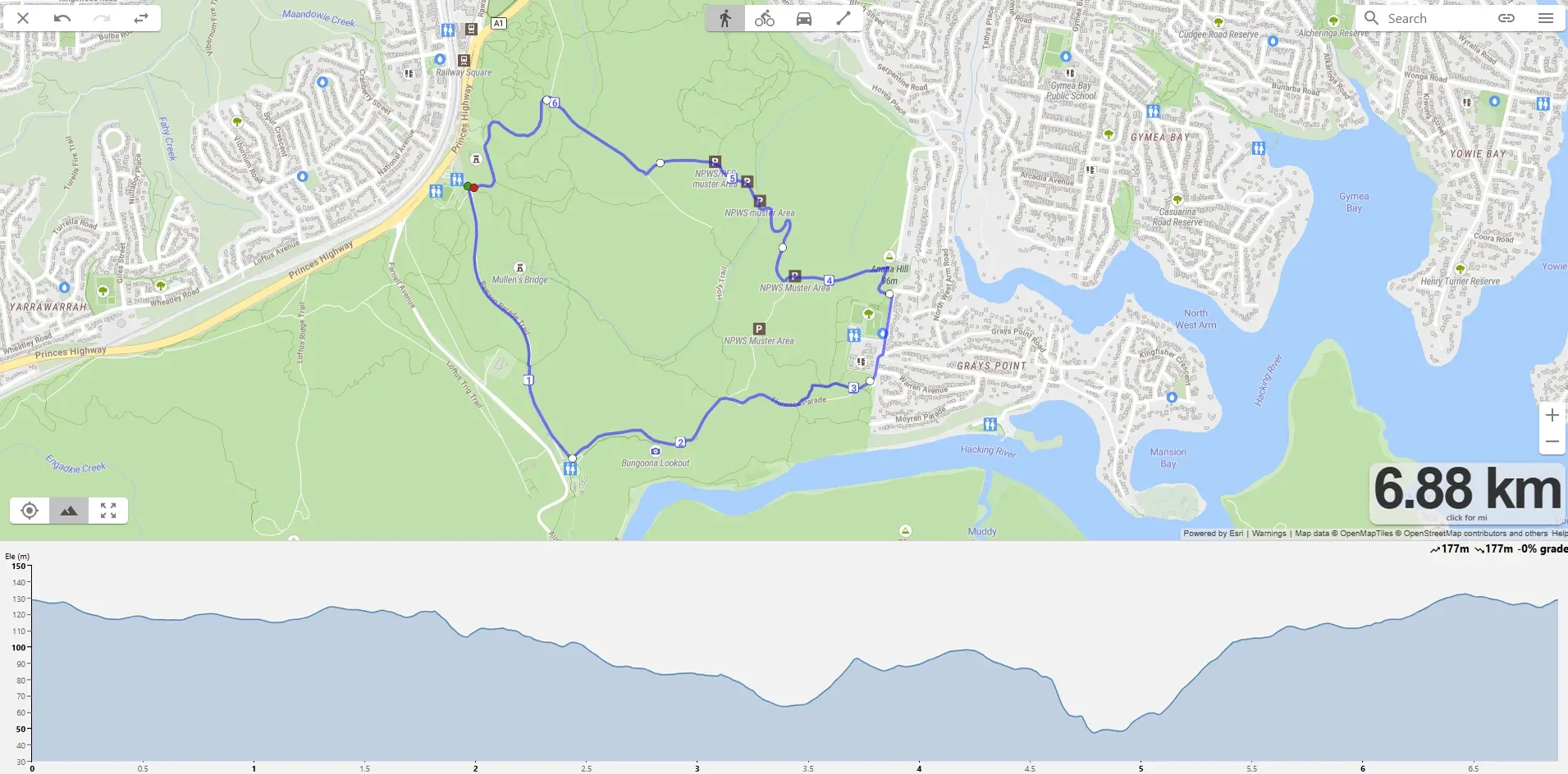
Temptation Creek Trail / Florence Parade Loop Trail Running Route
The trail entry point. Seven-kilometre loop on wide, well-graded fire trail, smooth enough to run at pace without thinking about footing, soft enough to feel different to road. Starts near Bungoona Lookout in the southern section of Royal NP and uses Temptation Creek Trail, Temptation Fire Trail, and Florence Parade to form a clean loop.
Good for runners who want to introduce trail without committing to coastal technical sections. The fire trail surface is fast underfoot, so this route can be used for tempo or threshold work on trail, which is unusual for Shire trail options.
Parking: Bungoona Lookout car park or Loftus Soccer Oval or Greenhaven Road, Gymea Bay.
Toilets: At Audley Visitor Centre (a short drive away). None at the trailhead.
Water: None on trail. Carry your own.
Public transport: Not practical. Car access required.
Best for: Trail tempo, threshold on softer surface, first-time trail runners building confidence.
Avoid: After heavy rain. Fire trail can stay muddy for days.
2. Cape Baily Track (Kurnell)
Distance: 6.2km return | Elevation: 301m | Surface: Mixed coastal track
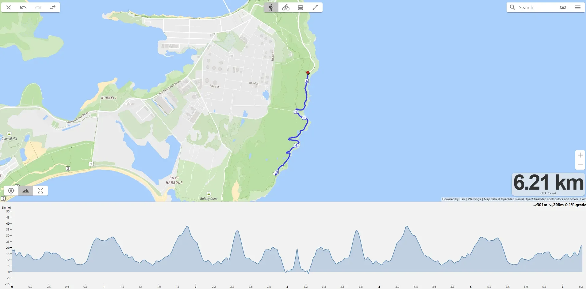
Cape Baily Kurnell Running Route
The most accessible trail in the Shire, no ferry required. Starts at Cape Solander car park in Kamay Botany Bay National Park and runs south along the clifftop to Cape Baily Lighthouse before returning the same way. Exposed clifftop the entire way, which is dramatic in good weather and brutal in bad. Whale watching from May to November is a regular feature.
The surface mixes rock platform, sandy track, and short boardwalk sections. Not technical in the way Royal NP coastal tracks get further south, but not a fire trail either. Footwork matters, particularly on the rock sections after rain.
Parking: Cape Solander car park, accessed from Cape Solander Drive in Kurnell. Free.
Toilets: Limited. Some at the car park, otherwise none on route.
Water: None on trail. Carry your own. Exposed clifftop means you will need more than you think in summer.
Public transport: Bus 987 to Kurnell from Cronulla, but service is limited. Car access easiest.
Best for: Short trail efforts, hilly aerobic work on rolling terrain, scenery.
Avoid: Summer afternoons. Full sun, no shade, exposed wind.
3. Bundeena to Marley Beach return
Distance: ~9km return | Elevation: 390m gain | Surface: Mixed Coast Track
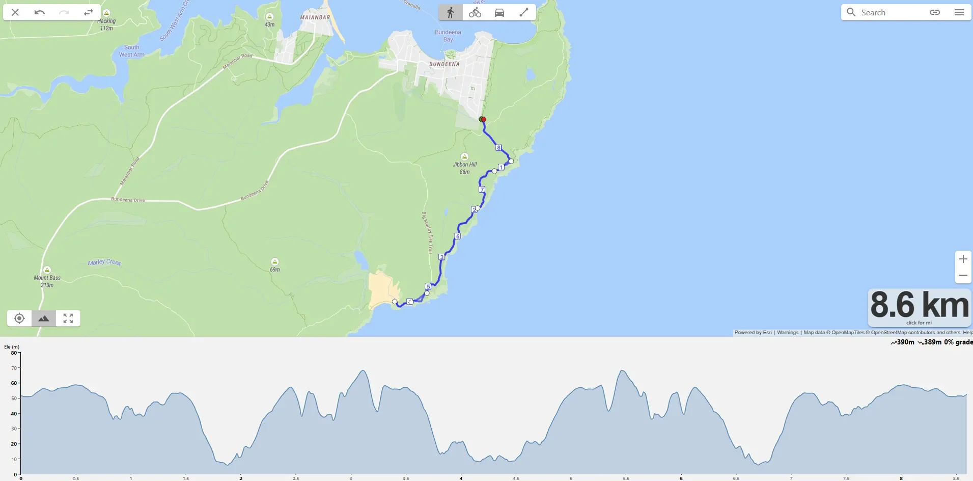
Bundeena to Marley Beach Running Route
The adventure trail run. Take the Cronulla to Bundeena ferry, run south along the Coast Track past Wedding Cake Rock to Marley Beach, then return. Technical sections, sandy patches, one boardwalk section, and views that don't appear on any other Shire route. The Coast Track is iconic enough that runners come from across Sydney to use it, and you've got it on your doorstep.
Pacing is harder than the surface suggests because the rolling terrain and exposed sections mean you can't switch off. Treat it as a 60-90 minute trail effort rather than a measured-distance session. The ferry timing means you can't be flexible about start times, so plan around the timetable.
Parking: Cronulla wharf has limited parking. Better to train to Cronulla or use the multi-storey car park near the station, then walk to the ferry.
Toilets: Bundeena Wharf, then nothing on the trail.
Water: Carry your own. There is no water source on the Coast Track.
Public transport: Train to Cronulla, then Curranulla ferry to Bundeena ($9.40 each way, not Opal). Ferry runs hourly.
Best for: Adventure long runs, training for trail races, anyone wanting to experience the best of Royal NP.
Avoid: Days with poor visibility. The clifftop sections are unforgiving in fog or strong wind.
4. Lady Carrington Drive
Distance: 10km one-way / ~20km return | Elevation: ~450m gain | Surface: Wide dirt and gravel
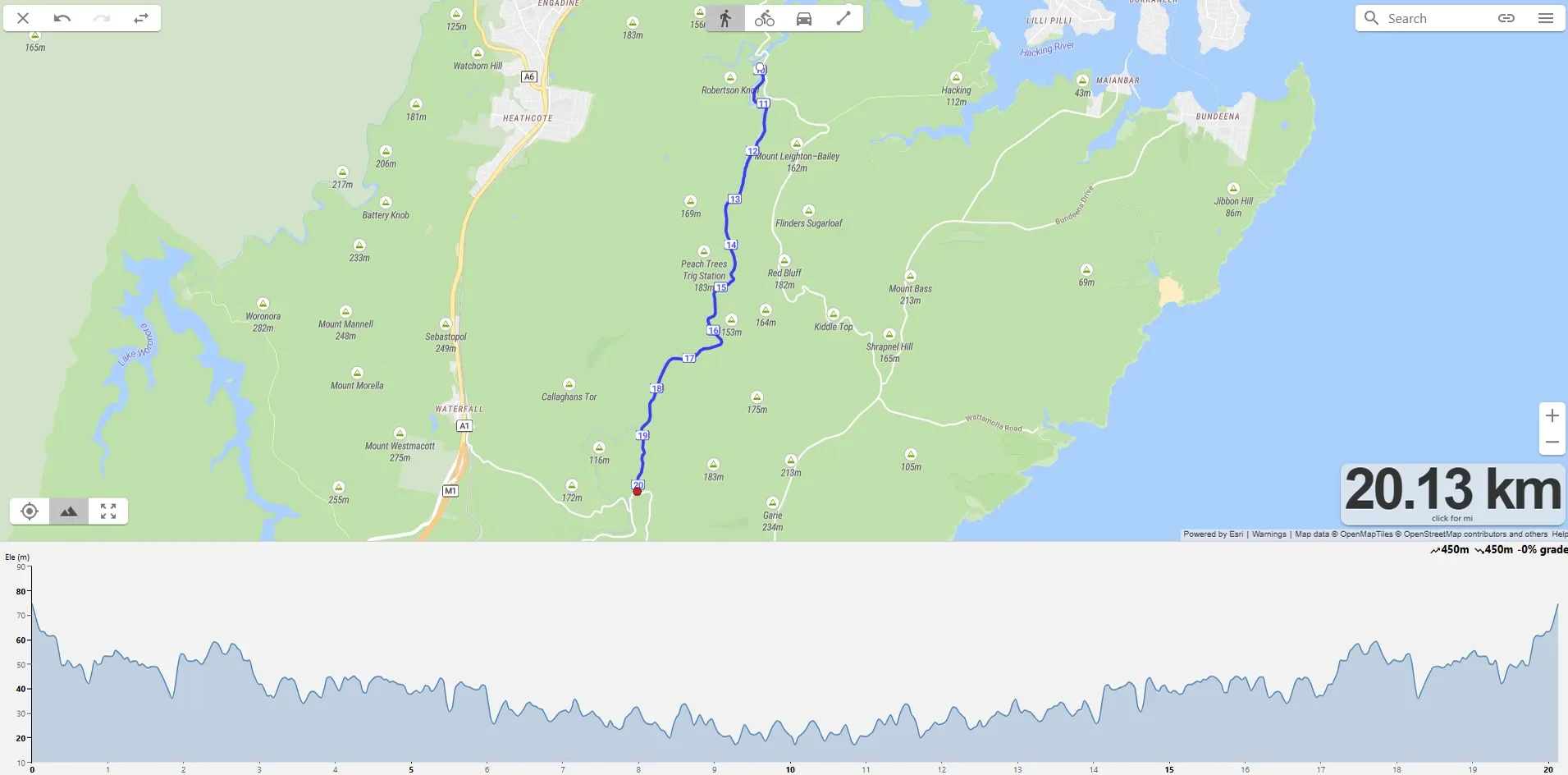
Lady Carrington Drive Trail Running Route
The trail long run option. Lady Carrington Drive is a former carriage road built in 1886, now closed to traffic and used by cyclists, walkers and runners. Wide, smooth dirt and gravel the whole way, gentle undulation, follows the Hacking River through dense bushland with rainforest sections. The kind of trail you can settle into and run for an hour without thinking about footing.
Run as a return trip from either end for the full 20km, or as a one-way shuttle if you can leave a car at Audley and another at the Sir Bertram Stevens Drive end. The route passes Palona Cave (worth a quick detour) and several picnic areas along the way. Better than Royal NP coastal options for sustained efforts because the surface is so consistent.
Parking: Audley Visitor Centre at the northern end (preferred, with toilets and café), or southern end off Sir Bertram Stevens Drive. $12 vehicle entry to Royal NP.
Toilets: Audley Visitor Centre at the north end. None elsewhere along the trail.
Water: Café at Audley sells water. None on trail itself.
Public transport: Loftus or Waterfall stations are within reach but require a long walk in. Car access more practical.
Best for: Trail long runs, marathon training on softer surface, anyone needing a long aerobic effort without traffic.
Avoid: Heavy rain (the trail gets boggy in sections), or summer middays without sun protection.
Where Are the Best Hill Running Routes in the Sutherland Shire?
Hills are the runner's equivalent of strength training. Repeated efforts up gradient build power, eccentric loading on the descents builds tissue capacity, and sustained climbs build aerobic threshold in a different way to flat tempo work. If you're doing dedicated strength and conditioning alongside your running, hill work complements that gym work directly. The three routes below give you three distinct stimuli. The Burraneer loop is short and punchy for hill reps, the Kareela loop is sustained climbing for hilly tempo or long run work, and the Engadine route is longer and rollier for hilly aerobic efforts. Match the route to the session.
1. Burraneer Hills: Burraneer Bay Road | Gannons Road | Port Hacking | Willarong
Distance: ~7km loop | Elevation: 155m gain | Surface: 73% paved residential streets
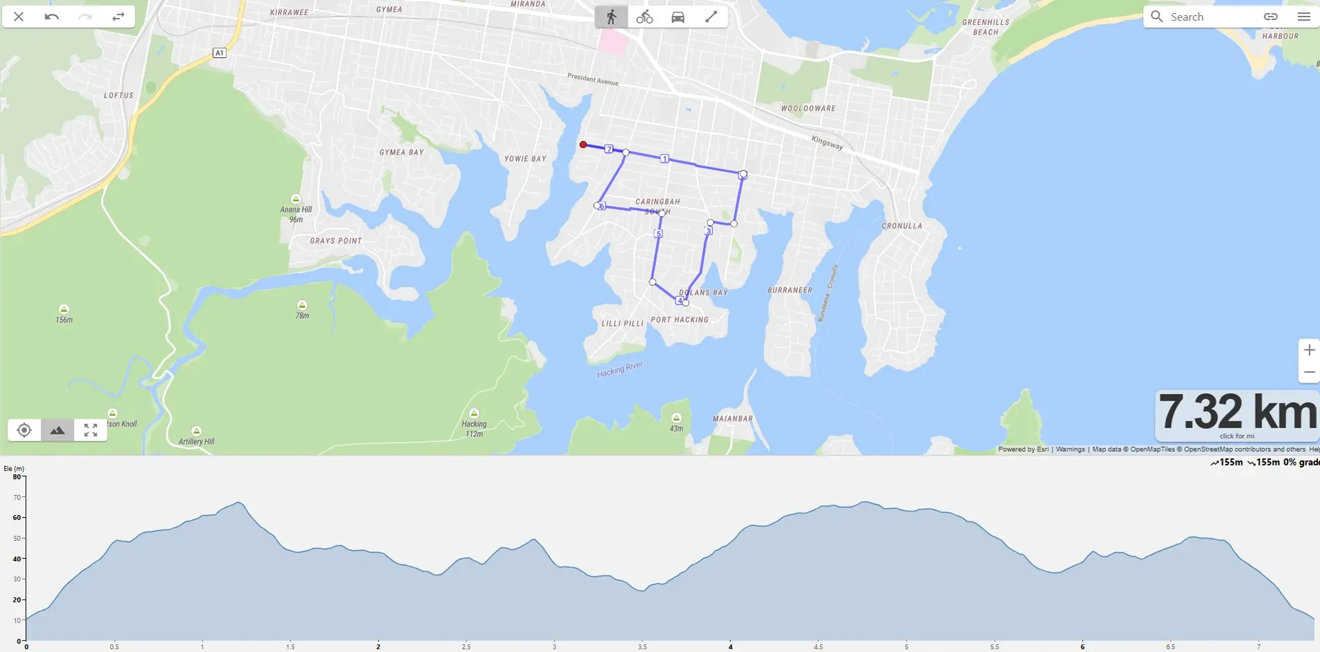
Burraneer Bay Hills Running Route
Seven-kilometre loop through the back streets of Burraneer with five or six distinct climbs across the route. The peninsula geography means you are never far from another short rise, which makes this the best Shire option for hill repeat sessions. Quiet residential streets, low traffic, and the intersections give you natural recovery points between efforts.
As a single loop it is a hilly tempo run. As a repeated loop (run it 2 or 3 times) it becomes a serious hill session. Some athletes prefer to isolate the steepest single climb and run repeats of just that segment, which works well if you have a specific power-development focus.
Parking: Street parking around Carmen Place Reserve at the start.
Toilets: Limited public toilets. Caringbah shops a short drive away.
Water: None on route. Bring your own.
Public transport: Woolooware station is the closest, about 1km walk from the start.
Best for: Hill reps, short hilly tempo, power development.
Avoid: Sessions where you need uninterrupted long climbs. The climbs here are short.
2. Jannali / Oyster Bay / Kareela
Distance: ~9.3km loop | Elevation: 276m gain | Surface: Path
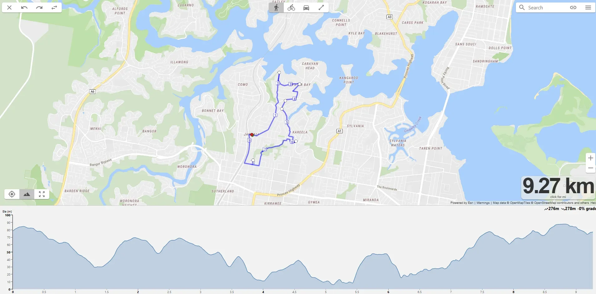
Jannali Oyster Bay Kareela Running Route
The sustained climbing option. This loop drops down through Oyster Gully bushland to around 5m above sea level then climbs back up to 83m, which gives you a proper sustained effort instead of repeated short reps. The mixed surface adds real value. All mainly paved/path.
Best used as a hilly tempo, marathon-pace work with elevation, or as part of a longer aerobic run where you want sustained climbing in the middle. The single biggest climb is the return out of Oyster Gully, which is long enough to feel meaningful.
Parking: Street parking around the Jannali start point.
Toilets: Jannali shops have public facilities.
Water: None on the loop. Bring your own.
Public transport: Jannali station is at the start. Easy train access.
Best for: Hilly tempo, marathon-pace efforts with sustained climbs, mixed-surface aerobic work.
Avoid: Running on the road, stick to paths and plan your route prior.
3. Engadine to Yarrawarrah
Distance: ~9km loop| Elevation: 190m gain across the return | Surface: Paved footpath
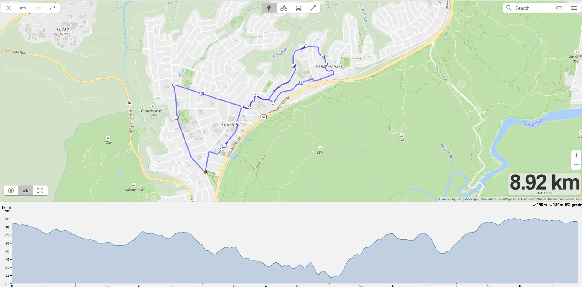
Engadine to Yarrawarrah Hilly Running Route
Lower gradient than the other two hill routes but the longest distance, which makes this the rolling aerobic option. Elevation rolls between 140m and 200m, so you are never on a flat section for long but you are never on a savage climb either.
Useful for hilly long runs where the goal is sustained effort over distance with elevation as a constant background stress, rather than discrete repeat efforts. Marathon training plans benefit from this kind of route in the middle of a long block.
Parking: Street parking around the Engadine end. Engadine station is also nearby if you train in.
Toilets: Engadine shops at the start. None along the route itself.
Water: Engadine shops at the start. Bring your own once you are moving.
Public transport: Engadine and Heathcote stations are both within walking distance of the route.
Best for: Hilly aerobic long runs, marathon-pace work with rolling elevation, longer threshold efforts.
Avoid: Weekday peak hours - all path.
Where Should You Do Interval and Tempo Sessions in the Sutherland Shire?
Where you run your hardest sessions matters. The track gives you measured distances for any interval session. A closed loop lets you run sustained tempo without navigating traffic. The three options below cover most of what an everyday athlete needs for structured speed and threshold work.
1. Sylvania Waters Athletics Track
Distance: 400m synthetic track | Surface: Synthetic | Booking: sutherland.bookable.net.au
The default Shire track. Measured distances, lane markings, the lot. Used by schools and clubs through the week, so the booking calendar is worth a check before turning up. Best for any interval session that requires consistent splits. Examples include 400s, 800s, 1km reps, mile reps, Yasso 800s, ladder workouts.
Parking: On-site car park.
Toilets: On-site. Often locked.
Water: Bring your own.
Public transport: Limited. Car access easiest.
Best for: Measured interval sessions, VO2 work, lactate threshold reps.
Avoid: Times when the booking calendar shows school or club use. Check before you go.
2. The Ridge Athletics Track, Barden Ridge
Distance: 400m synthetic track | Surface: Synthetic | Booking: sutherland.bookable.net.au
The Shire's other 400m option, less used than Sylvania. Worth knowing about for the times Sylvania is booked. Same booking system through Sutherland Shire Council. For most athletes, identical training value to Sylvania.
Parking: On-site car park.
Toilets: On-site. Sometimes open.
Water: Bring your own.
Public transport: Limited. Car access easiest.
Best for: Backup track when Sylvania is unavailable, southern Shire residents.
Avoid: Same as Sylvania. Check the booking calendar.
3. Green Hills Estate Loop
Distance: 1.9km loop | Surface: Sealed road | Elevation: Flat
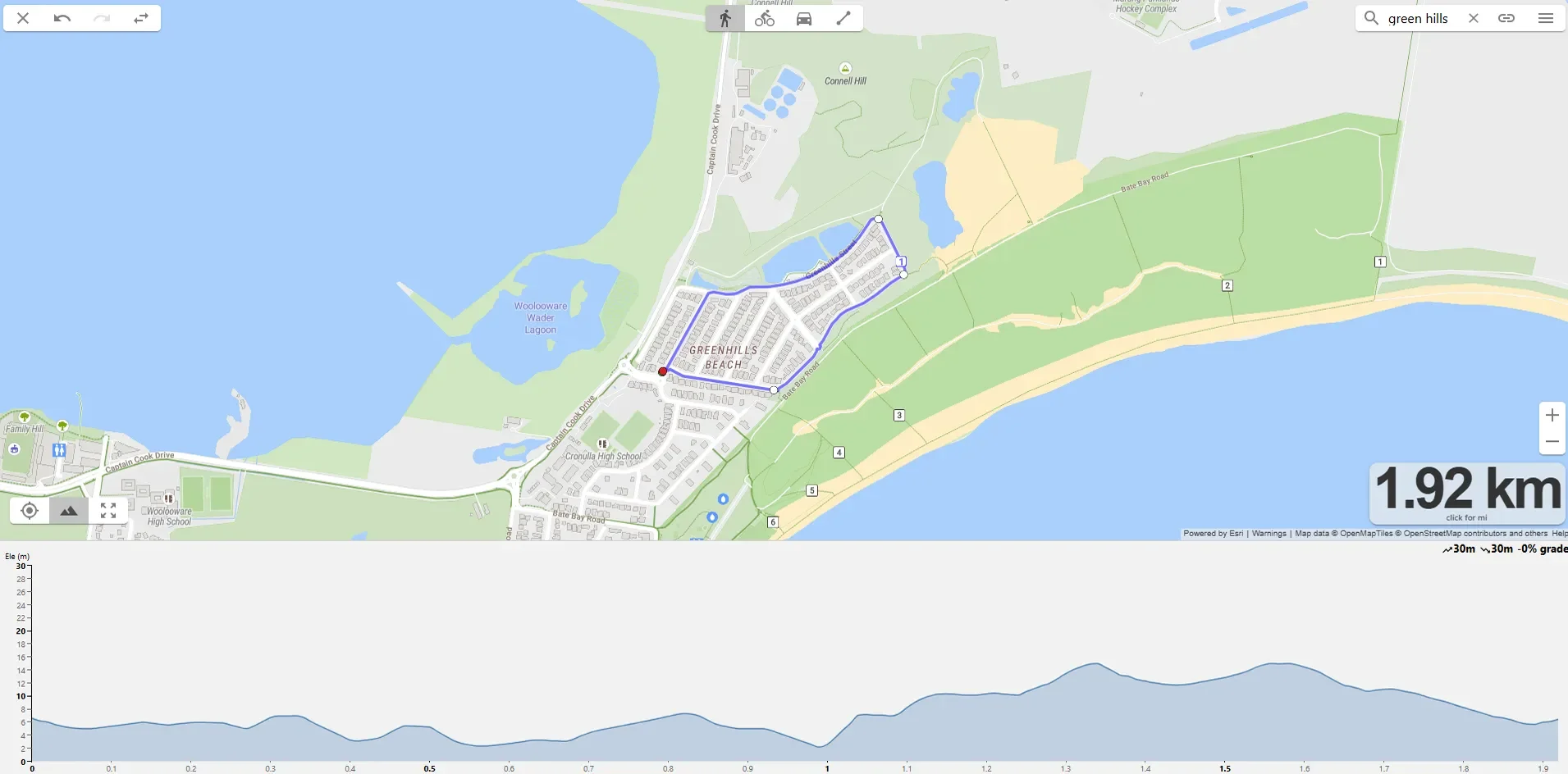
Cronulla Interval Session Running Routes
Estate road loop, repeatable, almost no through traffic. The 1.9km distance is the key feature. Long enough that a single loop is a meaningful tempo segment, short enough that you can build a session around multiple loops without losing rhythm. Three loops at marathon pace is roughly 5km of work. Five or six loops gives you a serious sustained threshold session of 8-10km. Eight loops at goal marathon pace is a full marathon simulation session in around 14km.
The closed-loop format also makes Green Hills useful for fartlek and varied-pace efforts where you don't want to navigate traffic, intersections, or strangers' driveways. Pace is on you, not on the route.
Parking: Street parking in the estate.
Toilets: None on site. Plan accordingly.
Water: Bring your own. You can leave a bottle on a kerb at the lap-point.
Public transport: Limited.
Best for: Tempo blocks, marathon-pace sustained efforts, fartlek where you want zero interruptions.
Avoid: Sessions requiring measured distance under 1.7km (use the track instead).
How Do You Match a Running Route to a Training Session?
Routes are infrastructure. The session you do on them is what builds the athlete. The four-category structure of this guide isn't decoration. It maps directly to the type of training stimulus each route delivers best. We use the engine and chassis framing at Evolve to talk about how different sessions build different parts of an athlete. Routes work the same way.
For aerobic base building and easy long runs, the Cronulla Esplanade is the default. Taren Point to Brighton works when you want a quieter alternative, and Kurnell gives you something different when monotony sets in. These flat predictable routes are where the bulk of weekly mileage should sit.
For trail aerobic and trail long runs, the four routes in Section 3 give you a clear progression. Temptation Creek for shorter trail efforts when you're starting out. Cape Baily when you don't want to deal with the ferry. Lady Carrington for genuine trail long runs of 20km. Bundeena to Marley when you want the experience as much as the training stimulus.
For hill repeats and power development, Burraneer or Kareela are the picks. Short, repeatable, high gain-per-km loops where you can structure discrete efforts. For hilly long runs and marathon strength work, Engadine to Yarrawarrah offers rolling sustained elevation across a longer distance.
For threshold, VO2, and measured interval work, head to Sylvania or Barden Ridge tracks for anything requiring exact distances. Green Hills loops are the answer for tempo blocks where the loop length itself becomes part of the session structure.
If you are not sure which session belongs in which part of your training week, that is a programming question rather than a route question. Variety is a tool, not a goal. Picking the right route is downstream of knowing why you are running today.
What Do You Need to Know Before Running These Routes?
Royal National Park fees. $12 vehicle entry per day for any of the Royal NP routes (Temptation Creek, Lady Carrington, Bundeena via car). Pay at Audley Visitor Centre or via the Park'nPay app. Cape Baily Track in Kurnell is in Kamay Botany Bay National Park and is currently free to enter, though the Visitor Centre is closed for upgrade works.
Bundeena ferry. Runs hourly from Cronulla wharf. $9.40 each way, payable on board by EFTPOS or card. Not part of the Opal network. Check the Curranulla ferry timetable before planning your run.
Summer heat. Most Shire routes are exposed. Cronulla Esplanade, Cape Baily, the Bundeena coastal section, and the hill loops all run with limited shade. In summer middays, plan for early starts and bring more water than you think you need. The wind that helps on the coast often disappears once you are inland.
Phone reception in Royal NP. Drops out across much of the park, particularly along Lady Carrington Drive and the southern Coast Track sections. Download maps offline before heading out. AllTrails or Strava routes saved offline are reliable. Tell someone your route and rough finish time for the longer trail efforts.
Track bookings. Both Sylvania and Barden Ridge tracks are bookable through Sutherland Shire Council. Schools and clubs use them through the week. The booking calendars are public and worth checking before turning up.
Strava and Garmin segments. Most of these routes have established Strava segments. Worth scanning the local Strava heatmap before heading out, particularly for the hill loops, to see which streets and climbs the local running community actually uses.
How Do You Put All of This Into a Training Plan?
Thirteen routes won't make you a better runner on their own. What makes the difference is the structure of how you use them, and the coaching framework that puts the right session on the right route at the right time in your training block. If you want help building that structure, Evolve coaches runners from beginners through to ultra athletes across the Sutherland Shire and Australia-wide via our online run coaching. We also run in-person strength and conditioning out of Caringbah for athletes who want the chassis work to match the engine work.
DM us @evolvehumanperformance or get in touch via the contact page if you want to talk about how this fits your training.
Frequently Asked Questions
Where is the best place to run in the Sutherland Shire?
Cronulla Esplanade is the default and works for most easy runs and long runs, with a flat paved surface and water on one side. If you want trail, Royal National Park has Lady Carrington Drive (20km return) and the Bundeena Coast Track. For hill work, Burraneer and Kareela offer the best gradients. The right route depends on the session you are running, not just preference.
Can you run trails in Royal National Park near the Sutherland Shire?
Yes, Royal National Park has four solid trail running options. Lady Carrington Drive is a wide dirt and gravel former carriage road at 20km return. Temptation Creek Trail is a 7km easy fire trail loop. The Bundeena to Marley Beach Coast Track is around 10km return with coastal clifftop terrain. Entry fees apply. Cape Baily Track in Kurnell is a fifth option that doesn't require Royal NP access.
Where are the best hill running routes in the Shire?
Three loops cover different hill training stimuli. The Burraneer Hills loop (7km, 154m elevation) is best for short hill reps. The Kareela / Jannali / Oyster Bay loop (9km, 276m) gives sustained climbing on mixed surfaces. The Engadine to Yarrawarrah return (9km, 190m) is the longest and rollier option for hilly aerobic work. All three are quiet enough for early morning sessions.
Where can I do a track session in the Sutherland Shire?
Two synthetic 400m athletics tracks. Sylvania Waters Athletics Track is the default option. The Ridge Athletics Track at Barden Ridge is the southern alternative. Both are bookable through Sutherland Shire Council and used by schools and clubs through the week, so check the booking calendar before turning up. For tempo work without measured distances, the 1.9km Green Hills Estate loop is the third option.
How do I get to Bundeena to run the Coast Track?
Take the Curranulla ferry from Cronulla wharf. It runs hourly, costs $9.40 each way, and accepts EFTPOS or card on board. The ferry is not part of the Opal network. The Coast Track starts at the junction of Eric Street and Beachcomber Avenue in Bundeena, about a 20-minute walk from the wharf. From there, running south to Marley Beach and back is roughly 10km.
Do I need a running coach to use these routes effectively?
Not necessarily. The routes work for any runner regardless of whether they are coached. What coaching adds is structure: knowing which session to run on which route, how to progress training load week to week, and how to manage strength work alongside running. If you find yourself doing the same loop for every run, or you keep picking up the same injuries, that is when coaching tends to make the most difference. Run coaching at Evolve is available in-person from Caringbah and online Australia-wide.
Want Someone in Your Corner?
If you want to know what coaching with Evolve looks like for your situation, the Run Coaching page has the detail on how it works. Or head to our contact page and let us know where you are at and what you are training for. Happy to point you in the right direction either way.